
JEFFERYS, Thomas.
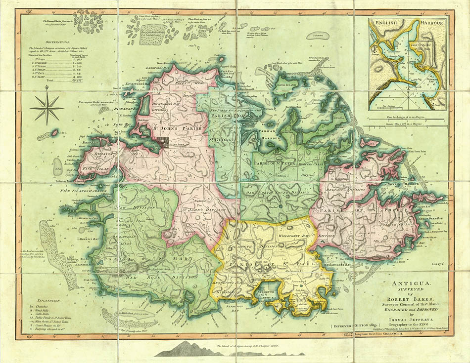
Antigua, surveyed by Robert Baker,
Antigua, surveyed by Robert Baker,
Surveyor General of that island: engraved and improved by Thomas Jefferys Geographer to the King.
Stock Code 84374
London, James Whittle & Richard Holmes Laurie, 1819
In 1749, Robert Baker published a four-sheet map of Antigua from his recent survey; in 1775, Thomas Jefferys prepared a single-sheet version for inclusion in his West India Atlas. Baker's map, the first survey of the whole island, in both wall-map and atlas format, is the most important map of the island before the new surveys of the early 1850s. The single-sheet version, a more manageable size, proved particularly popular and remained in circulation up until 1860.
This example was sold as a folding map, described as improved to 1819; this state not recorded in Tooley Printed Maps of Antigua.
Copper engraving, in original wash colour, dissected and mounted on linen, folding into the original green marbled slipcase with paper label, the map, widest: 491 x 615 mm.
Couldn't load pickup availability
Provenance
Provenance
Delivery
Delivery
We offer secure and express delivery on all local and international orders of rare books, maps and prints placed through this website.
About us
About us
Shapero Rare Books is an internationally renowned dealer in antiquarian & rare books and works on paper.
Our Bookshop and Gallery can be found in the heart of Mayfair at 94 New Bond Street, where most of our stock is available to view and on public display.
We exhibit at major international art fairs, including TEFAF (Maastricht and New York), Frieze Masters, Art Miami and Masterpiece London, as well as antiquarian & rare book fairs including New York, Paris, London, Los Angeles, San Francisco and Hong Kong.
Ask us a question
Ask us a question


BOOK COLLECTING IDEAS
THE BOND STREET BULLETIN
View all-

Introducing our New Department: Rare Science Books
Science Specialist Laura Massey introduces and gives an overview of eight new Science Categories Available to browse on our website.
UpdatesIntroducing our New Department: Rare Science Books
by Laura MasseyScience Specialist Laura Massey introduces and gives an overview of eight new Science Categories Available to browse on our website.
-

A Guide to Guidebooks
Karl Baedeker was head of a successful publishing business, when in 1832 he acquired the publishing house of Franz Röhling which four years earlier had published a travel guide Rheinreise...
GuidesA Guide to Guidebooks
by Lucinda BoyleKarl Baedeker was head of a successful publishing business, when in 1832 he acquired the publishing house of Franz Röhling which four years earlier had published a travel guide Rheinreise...
-

Ukrainian Modernism
The Royal Academy's new exhibition, In the Eye of the Storm: Modernism in Ukraine 1900-1930s, is the most comprehensive exhibition to date in the UK, celebrating a period of bold...
LiteratureUkrainian Modernism
A visit to the Royal Academy in London by Eleanor MooreThe Royal Academy's new exhibition, In the Eye of the Storm: Modernism in Ukraine 1900-1930s, is the most comprehensive exhibition to date in the UK, celebrating a period of bold...


